Hurricane Erin continues moving away from the coast, positioned more than 250 miles east of Cape Hatteras as of Thursday (Aug. 21, 2025). While the storm’s center is departing, significant hazards remain for the Eastern Shore of Virginia, including Tangier Island and all of Accomack County.
Current Storm Status
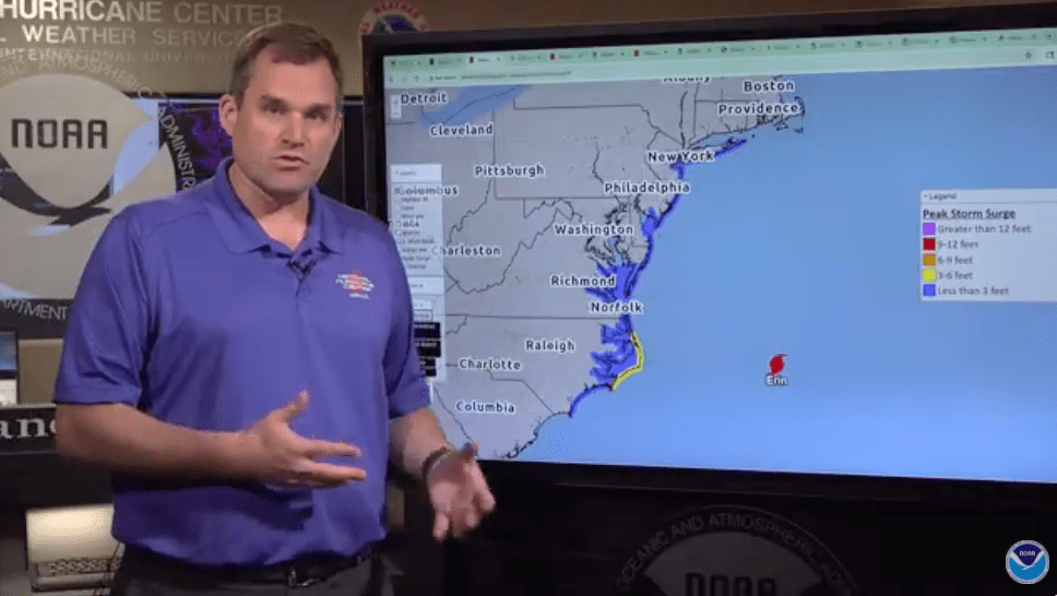
As of Thursday morning, Hurricane Erin’s maximum sustained winds have decreased to approximately 100 mph. However, the tropical storm-force wind field has expanded significantly, now extending more than 300 miles from the storm’s center.
Active Warnings for Our Area
- Tropical Storm Warning: Remains in effect for Accomack County and the Eastern Shore, extending from Beaufort Inlet, North Carolina up to Chincoteague, Virginia. Tropical storm-force winds are expected to continue as an approaching cold front enhances wind conditions across the Mid-Atlantic region over the next 24-36 hours.
- Coastal Flooding: Expected inundation of 1-3 feet above ground level for lower portions of the Chesapeake Bay and the Delmarva Peninsula. Residents in low-lying areas should remain prepared for flooding conditions.
- Tangier: The NOAA Water Prediction Service issued an Advisory for Moderate flooding on the island for Thursday night’s high tide (Aug. 21) through Friday night’s (Aug. 22) high tide. 3.75 feet is predicted for Aug. 21 at 11:51 p.m. and Friday’s (Aug. 22) daytime high tide at 12:09 p.m. Main Ridge Road and Post Office Road on Tangier Island begin to flood. Most homes on West Ridge Road are surrounded by water. In addition, the Tangier Fire Department and homes on Main Ridge Road south of Canton Road are surrounded by water. For Friday night’s high tide, at 12:36 a.m. Saturday, NOAA is predicting 3 inches higher than the 2 previous high tides. Take necessary precautions.
Transportation Alert
Chesapeake Bay Bridge-Tunnel: Currently operating under Level 1 wind restrictions. Not all vehicles can safely cross at this time. For current crossing conditions and vehicle restrictions, visit cbbt.com or call the facility directly before traveling.
Marine and Coastal Hazards
Dangerous Surf and Rip Currents: High-risk conditions continue along the entire Eastern Shore coastline through Sunday. The Atlantic Ocean will take considerable time to calm down even after Erin moves into the North Atlantic.
National Hurricane Center Director Michael Brennan emphasized: “Please pay attention to those beach warning flags. Stay out of the ocean if it does not appear safe.”
Extended Ocean Recovery: Ocean conditions will remain dangerous well beyond the storm’s departure. Mariners and beachgoers should exercise extreme caution and heed all local warnings.
Wind Concerns
Even as Erin’s core winds move away from our region, an approaching cold front will enhance wind conditions along the coast, affecting the Eastern Shore and extending into portions of southern New England through the next 24-36 hours. Residents should secure outdoor items and prepare for potentially damaging winds.
Staying Informed
This represents the final live briefing from the National Hurricane Center on Hurricane Erin. Continue monitoring conditions at:
- hurricanes.gov for storm updates
- weather.gov for local National Weather Service forecasts
- Accomack County Emergency Management for local conditions
- cbbt.com for bridge crossing status
Safety Reminders
- Avoid ocean activities until conditions improve
- Stay away from flooded roadways
- Secure loose outdoor items
- Check on neighbors, especially those who may need assistance
- Keep emergency supplies readily available
Residents of Tangier Island and throughout Accomack County should remain vigilant for ongoing coastal flooding, dangerous marine conditions, and enhanced winds through the weekend and into early next week.
