
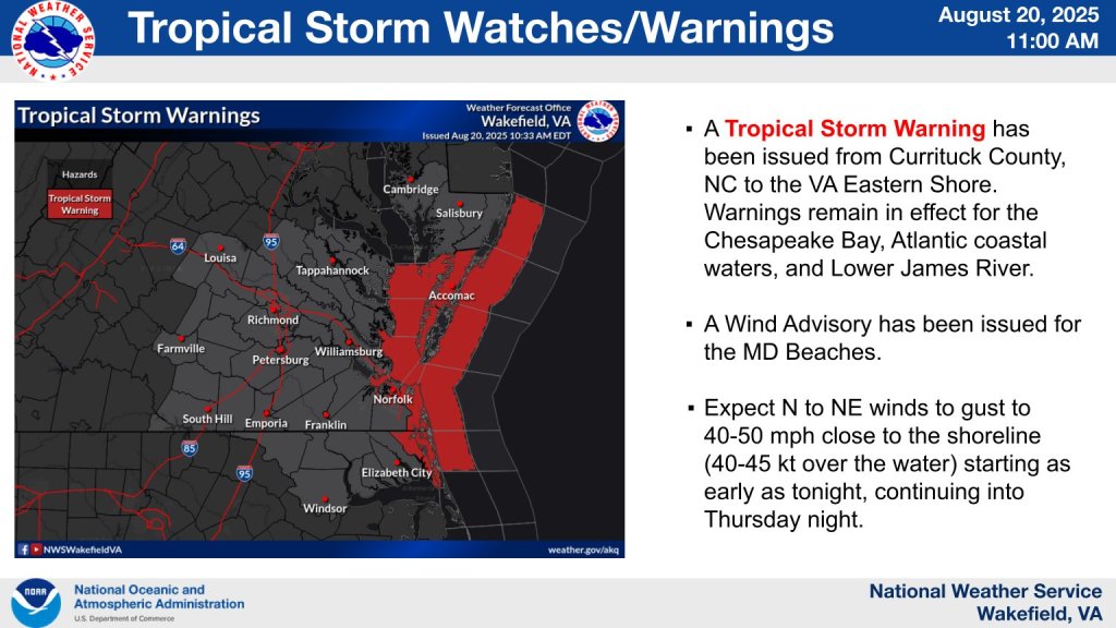
TANGIER, VIRGINIA – A TROPICAL STORM WARNING IS IN EFFECT for Accomack County until Saturday morning (Aug. 22, 2025) due to Hurricane Erin.
The storm, currently a Category 3 hurricane, is moving through the Atlantic Ocean off the U.S. East Coast. While the hurricane is not expected to make direct landfall, it poses significant threats to coastal communities due to its size.
What This Means for Tangier
Timing: The worst conditions are expected late this evening (Wednesday) through Friday evening.
National Weather Service Wakefield Forecast:
- Tropical-storm-force wind gusts of 40 to 50 mph along the coast
- Potential for tree damage and power outages
- Widespread minor to moderate coastal flooding Thursday/Friday
- Possibility of major flooding in some areas
- Beach and dune erosion from large swells
- Waves of 12 to 16 feet expected
Primary Hazards:
- Life-threatening surf conditions and rip currents
- Dangerous wind conditions that could down trees and power lines
- Significant coastal flooding
- Hazardous marine conditions
Accomack County Emergency Management Response
Accomack County Emergency Management is actively monitoring Hurricane Erin and coordinating response efforts. The county uses the CodeRED emergency notification system to alert residents of important updates and potential evacuation orders.
Virginia Emergency Officials’ Guidance: Virginia emergency response officials urge residents to prepare now for Hurricane Erin, emphasizing that inland flooding poses risks far beyond coastal areas. Officials stress the importance of taking warnings seriously to prevent unnecessary risks.
The Virginia Department of Emergency Management has created two digital emergency guides – one for coastal evacuation and another for inland residents with information on how to stay prepared and protected during hurricane events.
Key Information:
- No evacuation orders have been issued for Tangier at this time
- Emergency officials are monitoring conditions and will issue alerts as needed
- Six emergency shelter locations are available throughout Accomack County if needed
Safety Recommendations for Residents
Immediate Actions:
- Stay away from beaches, docks, and waterfront areas – waves up to 16 feet expected
- Prepare for possible power outages – charge devices and have backup power
- Secure or bring inside all loose outdoor items that could become projectiles in 40-50 mph winds
- Check emergency supply kits (water, food, medications, flashlights, batteries)
- Avoid unnecessary travel, especially near the waterfront
Stay Informed:
- Monitor local radio and television for official updates
- Sign up for Accomack County’s CodeRED emergency alerts
- Follow official county emergency management communications
- Avoid spreading unverified information on social media
Emergency Preparedness – Three Key Steps: As emphasized by Virginia emergency officials, the best protection for residents, emergency workers, and first responders is to:
- Make a Plan – Know your evacuation routes and family communication plan
- Make an Emergency Kit – Stock essential supplies now
- Stay Informed – Monitor official sources for updates
Marine Safety:
- All water activities should be avoided
- Boaters should secure vessels and avoid being on the water
- Dangerous conditions may persist even after the storm passes
Emergency Contact Information
- Accomack County Emergency Management: Monitor local radio and TV
- Emergency Services: Call 911 for emergencies only
- CodeRED Sign-up: Visit the Accomack County website
Next Update: We will provide updates as conditions change or when new information becomes available from Accomack County Emergency Management.
This information is based on current forecasts and may change.
