Published below is the Tangier Zoning Ordinance, adopted in 2008. A .pdf copy, which can be printed, is available below the text.
Tangier Zoning Ordinance
Town of Tangier, Virginia
Prepared by:
Tangier Planning Commission
With Technical Assistance Provided by:
Accomack-Northampton Planning District Commission
Adopted January 4, 2008
Council of the Town of Tangier, Virginia
The Honorable James Wyatt Eskridge, Mayor
Lewis S. Wheatley, Vice-Mayor
Teddy R. Marshall
Anna P. Parks
Michael R. Parks
Jamie L. Bradshaw
James R. Parks
Renee’ D. Tyler – Town Manager
Planning Commission
The Tangier Town Council
Table of Contents
Article 2 Residential-Mixed District R-M
Article 3 Waterfront Commercial District, C-W
Article 4 Chesapeake Bay Preservation Area Overlay District, CBPA
Article 7 Administration and Enforcement
Article 8 Plan of Development Requirements
List of Maps
Map 1 Town of Tangier Zoning Map
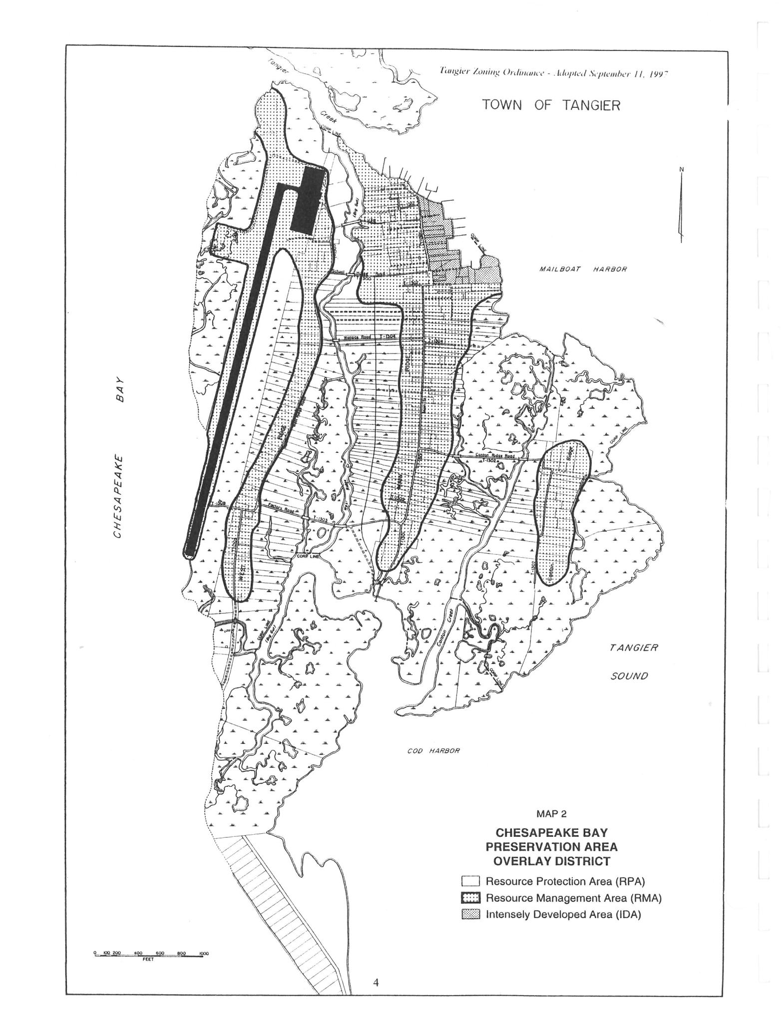
Map 2 Town of Tangier Chesapeake Bay Preservation Area Overlay District Map
Tangier Zoning Ordinance
ARTICLE 1 – GENERAL PROVISIONS
1-1. Title. This ordinance may be known, designated and cited as the “Tangier Zoning Ordinance.”
1-2. Authority. The Code of Virginia, Title 15.1, Chapter 11, Article 8, Section 15.1-486 through 15.1-498, empowers towns to enact zoning ordinances and to provide for their administration, enforcement and amendment, and states the purposes, powers, and procedures for municipal zoning.
1-3. Purpose. This ordinance is enacted to promote and protect the health, safety and general welfare of the people of the Town. It is the intention of the Town Council that the provisions of this ordinance will implement the purpose and intent of the comprehensive plan of the Town by encouraging the most desirable use of the land for residential, commercial, industrial, recreational, public service, drainage, and other purposes, and by encouraging the most appropriate use and occupancy of buildings, and by protecting and improving the quality of the waters within and adjacent to the Town, and by encouraging economic development activities that provide desirable employment and enlarge the tax base, and by promoting an attractive and harmonious community.
The governing body of the Town may, by ordinance, divide the territory under its jurisdiction into districts of such number, shape and area as it may deem best suited to carry out the purposes of this article, and in each district it may regulate, restrict, permit, prohibit, and determine the following:
A. The use of land, buildings, structures and other premises for commercial, industrial, residential, and other specific uses; and
B. The size, height, area, bulk, location, erection, construction, reconstruction, alteration, repair, maintenance, razing or removal of structures; and
C. The areas and dimensions of land, water and air space to be occupied by buildings, structures and uses, and of courts, yards and other open spaces to be left unoccupied by uses and structures, including variations in the sizes of lots based on whether a public or community water supply or sewer system is available and used; and
D. The excavation or minimum of soil or other natural resources.
Therefore, be it ordained by the governing body of the Town of Tangier, Virginia for the purpose of promoting the health, safety and/or general welfare of the public and of further accomplishing the objectives of Section 15.1-427 of the Code of Virginia, that the following be adopted as the zoning ordinance of the Town of Tangier, Virginia, together with the accompanying maps.
1-4. Jurisdiction. This ordinance shall apply to the incorporated territory of the Town of Tangier, Virginia. However, nothing contained herein shall require any changes in the plans or construction of any building for which a building permit was granted prior to the effective date of this ordinance. However, if such construction does not commence within six (6) months or less after this ordinance becomes effective, construction shall be in conformity with the provisions of this ordinance for the district in which the activity is located.
1-5. Town Liability. The zoning of any land and the granting of any permit or certificate for the use of land and/or structure shall not be interpreted as a guarantee by the Town of Tangier of the suitability of such land or structure for developing or use.
1-6. Severability Clause. Should any section or provision of this ordinance be declared by the courts to be unconstitutional or invalid, such decision shall not affect the validity of this ordinance as a whole or any other part thereof other than the part so declared to be unconstitutional or invalid.
1-7. Ordinance Sets Minimum Standards. Whenever the standards set forth in this ordinance conflict with the requirements of any other lawfully adopted statutes, rules, regulations, deed restrictions, covenants, or ordinances, the most restrictive, or that imposing the highest standards shall govern.
1-8. Zoning Districts and Regulations
A. Establishment of districts. In order to carry out the purposes and provisions of this ordinance, the incorporated area of the Town of Tangier is hereby divided into the following districts:
- Residential-Mixed; R-M
- Commercial-Waterfront; C-W
- Chesapeake Bay Preservation Area Overlay; CBPA
Location of these districts can be found on Map 1 and on Map 2.
B. Establishment of official zoning map. The Town of Tangier is divided into zoning districts, as shown on the official zoning map, which, together with all explanatory matter thereon, shall be a part of this ordinance.
C. Determination of district boundaries. Unless zoning district boundary lines are fixed by dimensions or otherwise clearly shown as described, and where uncertainty exists with respect to the boundaries of any zoning districts as shown on the zoning maps, the following rules shall apply:


1. Where district boundaries are indicated as approximately following or being at right angles to the center lines of streets or alleys, such center lines or lines at right angles to such center lines shall be construed to be such boundaries, as the case may be.
2. Where a district boundary is indicated to follow a creek, branch or other body of water, such boundary shall be construed to follow the center line at low water or at the limit of the jurisdiction, and in the event of change in the shoreline, such boundary shall be construed as moving with the actual shoreline.
3. If no distance, angle, curvature description, or other means is given to determine a boundary line accurately and the above provisions do not apply, the boundary line shall be determined by the administrative authority using the scale shown on the zoning map. In case of subsequent dispute, the matter shall be referred to the Board of Zoning Appeals, which shall determine the boundary.
1-9 General Performance Criteria. The following standards shall apply in all zoning districts in the Town of Tangier.
A. Land disturbance shall be limited to the area necessary to provide for the proposed use or development.
B. Existing vegetation shall be preserved to the maximum extend practicable consistent with the use or development proposed and in accordance with the Virginia Erosion and Sediment Control Handbook.
C. Development and Redevelopment exceeding 2,500 square feet.
1. All development and redevelopment exceeding 2,500 square feet of land disturbance shall be subject to a plan of development process, in accordance with Article 8 -Plan of Development Requirements, of this Zoning Ordinance.
2. Notwithstanding any other provisions of this Article or exceptions or exemptions thereto, any land disturbing activity exceeding 2,500 square feet, including construction of all single-family houses, septic tanks, and drain-fields, shall comply with the requirements of the Accomack County Erosion And Sediment Control Ordinance.
ARTICLE 2 – RESIDENTIAL-MIXED DISTRICT, R-M
2-1. Title. This district shall be known and referenced as the “Residential-Mixed District” of the Town of Tangier, Virginia.
Statement of Intent. This district is composed of quiet, medium-density residential areas plus certain open areas where similar residential development is recommended to occur by Tangier Town Plan. The regulations for this district are designed to stabilize and protect the essential characteristics of the district, and to promote and encourage a suitable environment for family life where there are children. To these ends, development is limited to a relatively medium concentration; and permitted uses are basically limited to single-unit dwellings providing homes for the residents, plus certain additional uses, such as parks, and certain public facilities that serve the residents of the district. This area is represented as R-M on page three of the Tangier Zoning Ordinance and as Residential on the Future Land Use Map in the Tangier Town Plan.
2-2. Principal Permitted Uses and Structures. The following uses shall be permitted subject to all other requirements of this ordinance as a matter of right in Residential-Mixed District (R-M).
A. Single-Family Dwellings.
B. Two-Family Dwellings.
C. Parks and Playgrounds.
D. Accessory Buildings.
E. Public Utilities: poles, distribution lines, distribution transformers, pipes, meters, and other facilities necessary for the provision and maintenance of public utilities, including water and sewage facilities.
2-3. Special Exceptions. The following uses shall be permitted in R-M, subject to all the other requirements of this ordinance, only upon the obtaining of a Special Exception Permit from the Town Council.
A. Home Occupations.
B. Churches.
C. Bed and Breakfast Houses.
D. Retail sales and service stores.
E. Restaurants.
F. Boarding houses.
2-4. Setback Regulations. The following setback regulations shall apply in R-M:
A. Front. Each main building shall have a minimum front yard setback of 10 feet from lot line.
B. Side. Each main building shall have a minimum side yard setback of three (3) feet from the lot line. Any one (1) story accessory building shall have a setback of three (3) feet and any accessory building over one (1) story shall have a setback of three (3) feet.
C. Rear. Each main building shall have a rear yard setback of three (3) feet from lot line. Any one (1) story accessory building shall have a setback of three (3) feet and accessory building over one (1) story shall have a setback of three (3) feet.
2-5. Height Regulations. Buildings may be erected up to 35 feet and two and one-half (2 1/2) stories in height except that:
A. Public utility structures, church spires, belfries, cupolas, monuments, water towers, chimneys, flues, flag poles, residential television antennae and residential radio aerials are exempt. Parapet walls may be up to four (4) feet above the height of the building on which the walls rest.
B. Accessory buildings shall be limited to two (2) stories in height.
ARTICLE 3 – WATERFRONT COMMERCIAL DISTRICT, C-W
3-1. Title. This district shall be known and referenced as the “Waterfront Commercial District” of the Town of Tangier, Virginia.
3-2. Statement of Intent. This district is intended to provide for the conduct of a variety of commercial activities and services related to the seafood and tourism industries. In addition, recreational use of the harbor is allowed. All uses should be on a scale compatible with the adjacent residential uses. This area is represented by C-W on page three of the Tangier Zoning Ordinance and as Commercial, Waterfront on the Future Land Use Map in the Tangier Town Plan.
3-3. Principal Permitted Uses and Structures. The following uses shall be permitted by right.
A. All uses permitted in R-M.
B. Seafood Packing and Processing Plants, including crab shedding operations.
C. Welding Shops.
D. Boat Yards, Boat Repair.
E. Restaurants.
F. Launch Ramps.
G. Retail Sales and Service Stores.
H. Public Utilities: poles, distribution lines, distribution transformers, pipes, meters and other facilities necessary for the provision and maintenance of public utilities, including water and sewage facilities.
I. Drainage, erosion and flood control devices.
3-4. Special Exceptions. The following uses shall be permitted in Waterfront Commercial District (C-W), subject to all other requirements of this ordinance, only upon the obtaining of a Special Exception permit from the Town Council.
A. Professional and business offices.
- Bed and Breakfast operations.
- Residential apartments above stores.
D. Boarding houses.
3-5. Minimum Lot Area. None, except for those uses permitted in R-M. The area regulations in R-M shall apply to R-M uses.
3-6. Setback Regulations. The following are the yard regulations for C-W:
A. C-W uses which use a side or rear yard must have a minimum side yard of five (5) feet and a minimum rear yard of five (5) feet.
B. C-W uses that are adjacent to a residential district must have a minimum side yard of 10 feet and a minimum rear yard of 20 feet.
3-7. Height Regulations. Buildings may be erected up to 35 feet and two and one-half (2 1/2) stories in height except that:
A. Public utility structures, church spires, belfries, cupolas, monuments, water towers, chimneys, flues, flag poles, residential television antennae and residential radio aerials are exempt. Parapet walls may be up to four (4) feet above the height of the building on which the walls rest.
B. Accessory buildings shall be limited to two (2) stories in height.
3-8. Access. Each main building shall front on a street or 12 foot minimum width access easement.
ARTICLE 4 – CHESAPEAKE BAY PRESERVATION AREA OVERLAY DISTRICT, CBPA
4-1. Title. This district shall be known and referenced as the “Chesapeake Bay Preservation Area Overlay District” of the Town of Tangier, Virginia.
4-2 Purpose and Authority. It is the intent of the Town of Tangier, Virginia and this overlay district to protect, improve and enhance the waters of the Chesapeake Bay, its tributaries and other state waters. This Article is enacted under the authority of Section 10.1-2100 et seq. (The Chesapeake Bay Preservation Act) and Section 15.2-2283 of the Code of Virginia.
4-3 Conflict with Other Regulations. In any case where the requirements of this Article conflict with any other provision of the Town of Tangier Code or existing state or federal regulations, whichever imposes the more stringent restrictions shall apply.
4-4 Application of CBPA District.
A. The Chesapeake Bay Preservation Area Overlay District (CBPA) shall apply to all lands identified as Chesapeake Bay Preservation Areas as designated by the Town of Tangier Town Council and as shown on the Town of Tangier Zoning Map as the Chesapeake Bay Preservation Area Overlay District. The Chesapeake Bay Preservation Area Overlay District is composed of a Resource Protection Area and a Resource Management Area.
1. Resource Protection Areas (RPAs) include the following land categories, the protection of which is necessary to protect the quality of state waters:
a. Tidal wetlands;
b. Nontidal waters connected by surface flow and contiguous to tidal wetlands or water bodies with perennial flow
c. Tidal shores;
d. A 100 foot vegetated buffer area located adjacent to and landward of the components listed in subsections a. through c. above and along both sides of any water body with perennial flow.
2. Resource Management Areas (RMAs) are generally composed of the following land categories: floodplains; highly permeable soils; nontidal wetlands not included in the RPA; and hydric soils.
- The Town of Tangier Zoning Map shows the general location of CBPA’s and should be consulted by persons contemplating activities within the Town of Tangier prior to engaging in a regulated activity.
C. Portions of RPAs and RMAs designated by the Town Council as Intensely Developed Areas (IDAs) shall serve as redevelopment areas. Areas so designated shall comply with all Erosion and Sediment Control requirements in Section 1-9.C.2 and the stormwater management requirements in Section 4-9.B.1 b.
4-5 Interpretation of Resource Protection Area Boundaries. The site-specific boundaries of the Resource Protection Area shall be delineated by the applicant through the submission of a plot or site plan as required under Article 8 or through the review of a water quality impact assessment as Required under Section 4-10, subject to approval by the Administrator.
4-6 Use Regulations. Permitted uses, special permit uses, accessory uses, and special requirements shall be as established by the underlying zoning district, unless specifically modified by the requirements set forth herein.
4-7 Lot Size. Lot size shall be subject to the requirements of the underlying zoning district(s), provided that any lot shall have sufficient area outside the RPA to accommodate an intended an intended development in accordance with the performance standards in Section 4-9, Performance Standards, when such development is not otherwise allowed in the RPA.
4-8 Required Conditions.
A. Development in the RPA may be allowed only when permitted by the Administrator and if it (i) is water dependent; (ii) constitutes redevelopment or development within the IDA; or (iii) constitutes redevelopment.
B. A water quality impact assessment shall be required for any proposed land disturbance, development or redevelopment within the RPAs or when required by the Administrator because of the unique characteristics of the site or intensity of development, in accordance with the provisions of Section 4-10, Water Quality Impact Assessment, of this Article.
C. Redevelopment outside of the IDA shall be permitted in the Resource Protection Area only if there is no increase in the amount of impervious cover and no further encroachment within the Resource Protection Area and it conforms with the erosion & sediment control requirements in Section 1-9.C.2 and stormwater management requirements in Section 4-9.B.1 of this Article.
D. A new or expanded water-dependent facility may be allowed provided that:
1. It does not conflict with the Tangier Town Plan;
2. It complies with the performance criteria set forth in Section 1- 9 and 4-9.B of this Article;
3. Any non-water-dependent component is located outside of Resource Protection Areas;
4. Access will be provided with the minimum disturbance necessary. Where possible, a single point of access will be provided.
4-9 Performance Standards.
A. Purpose and Intent
It is the intent of these requirements to prevent a net increase in nonpoint source pollution from new development and achieve a 10% reduction in nonpoint source pollution from redevelopment.
B. General Performance Standards for development and Redevelopment.
1. For any development and redevelopment, stormwater runoff shall be controlled by the use of best management practices that achieve the following:
a. For development, the post-development nonpoint source pollution runoff shall not exceed the pre-development load, based on the calculated average land cover condition for the Chesapeake Bay watershed as 16% or 45 pounds per acre per year.
b. For redevelopment sites, the nonpoint source pollution load shall be reduced by at least 10%. The Administrator may waive or modify this requirement for redevelopment sites that originally incorporated Best management practices for storm water runoff quality control, provided the following provisions are satisfied:
(1) In no case may the post-development nonpoint source pollution runoff load exceed the pre-development load;
(2) Runoff polution loads must have been calculated and the best management practices selected for the expressed purpose of controlling nonpoint source pollution;
(3) If best management practices are structural, evidence shall be provided that facilities are currently in good working order and performing at the design levels of service.
c. For redevelopment, both the pre- and the post-development loadings shall be calculated by the same procedures. However, where the design data is available, the original post-development nonpoint source pollution loadings can be substituted for the existing development loadings.
2. Prior to initiating grading or other on-site activities on any portion of a lot or parcel, all wetlands permits required by federal, state, and local laws and regulations shall be obtained and evidence of such submitted to the Administrator, in accordance with Article 8, Plan of Development Requirements, of this Zoning Ordinance.
3. Buffer Area Requirements. To minimize the adverse effects of human activities on the other components of Resource Protection Areas, state waters, and aquatic life, a 100-foot buffer area of vegetation that is effective in retarding runoff, preventing erosion, and filtering nonpoint source pollution from runoff shall be retained if present and established where it does not exist.
The buffer area shall be located adjacent to and landward of other RPA components and along both sides of any water body with perennial flow. The full buffer area shall be designated as the landward component of the RPA, in accordance with Section 4-4, Application of CBPA District, and Article 8, Plan of Development Requirements, of this Zoning Ordinance.
The 100-foot buffer area shall be deemed to achieve a 75% reduction of sediments and a 40% reduction of nutrients.
The buffer area shall be maintained to meet the following additional performance standards:
1. In order to maintain the functional value of the buffer area, existing vegetation may be removed, subject to approval by the Zoning Administrator, only to provide for reasonable sight lines, access paths, general woodlot management and best management practices, including those that prevent upland erosion and concentrated flows of storm water, as follows:
a. Any path shall be constructed and surfaced so as to effectively control erosion.
b. For shoreline erosion control projects, woody vegetation may be removed, necessary control techniques employed, and appropriate vegetation established to protect or stabilize the shoreline in accordance with the best available technical advice and applicable permit conditions or requirements.
2. When the application of the buffer areas would result in the loss of a buildable area on a lot or parcel recorded prior to October 1, 1989, the Administrator may permit encroachments into buffer area in accordance with Article 8, Plan of Development Requirements, of this Zoning Ordinance and the following criteria:
a. Encroachment into the buffer area shall be the minimum necessary to achieve a reasonable buildable area for principal structure and necessary utilities;
- Where practicable, a vegetated area that will maximize water quality protection, mitigate the effects of the buffer encroachment, and is equal to the area of encroachment into the buffer area shall be established elsewhere on the lot or parcel; and
- The encroachment may not extend into the seaward 50 feet of the buffer area
3. Redevelopment within the IDA maybe exempt from the buffer area, in accordance with Article 8, Plan of Development Requirements, of this Ordinance.
4-10. Water Quality Impact Assessment.
A. Purpose and Intent. The purpose of the water quality impact assessment is to identify the impacts of proposed development on water quality and lands within RPAs and other environmentally sensitive lands; ensure that, where development does take place within Resource Protection Areas and other sensitive lands, it will be located on those portions of a site and in a manner that will be least disruptive to the natural functions of Resource Protection Areas and other sensitive lands; to protect individuals from investing funds for improvements proposed for location on lands unsuited for such development because of high ground water, erosion, or vulnerability to flood and storm damage; and specify mitigation which will address water quality protection.
B. Water Quality Impact Assessment Required. A water quality impact assessment, to be submitted during the plot plan, site plan and /or subdivision review process, is required for:
1. Any proposed land disturbance, development or redevelopment within a Resource Protection Area, including any buffer area encroachment as provided for in Section 4-10.C
2. Any proposed development of redevelopment within an RMA. The Administrator may waive this requirement when it is apparent that the unique characteristics of the site (such as the topography, soils, groundcover, location of wetlands and tidal shores) will prevent the proposed development from causing a degradation of water quality.
C. Contents of a Water Impact Assessment. The water quality impact assessment shall be of sufficient specificity to demonstrate compliance with this Article. The information required in the Section shall be considered a minimum; the Administrator may determine that additional information is necessary due to the nature and scope of the proposed use and development of land. The impact statement shall be prepared by qualified persons acting within the limits of their professional expertise and license, and shall include the following:
- Location of the components of the RPA, including the one hundred (100) foot RPA buffer and location of any water body with perennial flow.
2. Location and nature of any proposed encroachments into the RPA buffer area including the type of paving material; areas of clearing or grading; and the location of any structures, driveways and other impervious cover.
3. Type and location of proposed storm water management facilities and best management practices necessary to comply with performance standards for storm water management contained in Section 4-9.B.
4. Calculation of pre- and post- development pollutant loading in accordance with Section 4-9.B.
5. Identification and status of any required wetlands permits from federal, state or local agencies.
6. An erosion and sediment control plan in accordance with the requirements of Accomack County’s Erosion and Sediment Control Ordinance.
7. A narrative describing the site; the impacts of the proposed development on topography, soils, hydrology and geology; and the measures taken to mitigate nonpoint source pollution.
D. Evaluation Procedure.
1. Upon the completed review of a water quality impact assessment, the
Administrator will determine if the proposed encroachment into the buffer area is consistent with the purpose and intent of this Article or if the proposed development is consistent with the purpose and intent of this Article.
2. The Administrator may request review of the water quality impact
assessment by the Division of Chesapeake Bay Local Assistance (DCBLA). Any comments by DBLA will be considered by the Planning Commission provided that such comments are provided by DCBLA within 30 days of the request.
4-11. Exemptions.
- Exemptions for Utilities, Railroads, and Public Roads.
- Construction, installation, operation, and maintenance of electric, natural gas, fiber optic and telephone transmission lines, in accordance with (i) regulations promulgated pursuant to the Erosion and Sediment Control Law(Section 10.1-560 et seq. of the Code of Virginia) and the Stormwater Management Act, (ii) erosion and sediment control plan and a stormwater management plan approved by the Virginia Department of Conservation and Recreation, or (iii) local water quality protection criteria at least as stringent as the above state requirements will be deemed to constitute compliance with the Article.
2. Construction, installation, and maintenance of water, sewer, natural gas and underground telecommunications and cable television lines owned, permitted or both by the Town of Tangier shall be exempt from the Overlay District provided that:
a. To the degree possible, the location of such utilities and facilities shall be outside the RPAs:
b. No more land shall be disturbed than is necessary to provide for the proposed utility installation;
c. All construction, installation, and maintenance of such utilities and facilities shall be in compliance with all applicable state and federal requirements and permits and designed and conducted in a manner that protects water quality; and
d. Any land disturbance exceeding an area of 2,500 square feet complies with all Accomack County erosion and sediment control requirements.
B. Exemptions in Resource Protection Areas. The following land disturbances in RPAs may be exempted from the Overlay District: (i) water wells; (ii) passive recreation facilities such as boardwalks, trails, and pathways: and (iii) historic preservation and archaeological activities, provided that it is demonstrated to the satisfaction of the Administrator that:
1. Any required permits, except those to which this exemption specifically applies, shall be issued:
2. Sufficient and reasonable proof is submitted that the intended use will not deteriorate water quality:
3. The intended use does not conflict with nearby planned or approved uses; and
4. Any land disturbances exceeding an area of 2,500 square feet shall comply with all Accomack County erosion and sediment control requirements.
4-12. Exceptions.
A. A request for an exception to the requirements of Sections 4-8 and 4-9.C shall be made in writing to the Board of Zoning Appeals. It shall identify the impacts of the proposed exception on water quality and on lands within the RPA through the performance of a water quality impact assessment which complies with the provisions of Section 4-10.
B. The Town of Tangier shall notify the affected public of any such exception requests and shall consider these requests in a public hearing in accordance with Section 15.2-2204 of the Code of Virginia, except that only one hearing shall be required.
C. The Board of Zoning Appeals shall review the request for an exception and the water quality impact assessment and may grant the exception with such condition and safeguards as deemed necessary to further the purpose and intent of this Article if the Board of Zoning Appeals finds:
1. Granting the exception will not confer upon the applicant any special privileges that are denied by this Article to other property owners in the Overlay District;
2. The exception request is not based upon conditions or circumstances that are self-created or self-imposed, nor does the request arise from conditions or circumstances either permitted or non-conforming that are related to adjacent parcels;
3. The exception request is the minimum necessary to afford relief;
4. The exception request will be in harmony with the purpose and intent of the Overlay District, and not injurious to the neighborhood or otherwise detrimental to the public welfare or substantial detriment to water quality; and
5. Reasonable and appropriate conditions are imposed which will prevent the exception request from causing a degradation of water quality.
D. If the Board of Zoning Appeals cannot make the required findings or
refuses to grant the exception, the Board of Zoning appeals shall return the request for an exception together with rationale for the decision to the applicant.
E. A request for an exception to the requirements of provisions of this Article other that Sections 4-8.A and 4-9.C shall be made in writing to the Administrator. The Administrator may grant these exceptions provided that:
(1) Exceptions to the requirements are the minimum necessary to afford relief; and
(2) Reasonable and appropriate conditions are placed upon any exception hat is granted, as necessary, so that the purposed and intent of this Article is preserved.
(3) Exceptions to Sections 1-9 and 4-9.B may be made provided that the findings noted in Section 4-12.C are made.
ARTICLE 5 – SIGN REGULATIONS
5-1. Statement of Purpose. The following sign regulations are established to assure compatibility of signs with surrounding land usage, to enhance the economy of the Town, to preserve natural beauty and to promote the reasonable, orderly and effective display of outdoor advertising.
5-2. Advertising Outdoors Regulated. No person except a public officer or employee in performance of a public duty shall paste, post, paint, print, nail, tack, erect, place, maintain, or fasten any sign, pennant, flags, outdoor advertising signs, billboard, or notice of any kind, or cause the same to be done, facing or visible from any public street or public open space, except as provided herein.
5-3. Signs Permitted by Right The following signs are permitted by right, subject to other applicable provisions of this Article.
A. Business. A business sign is defined as a sign which directs attention to a product, commodity, or service available on the premises. Signs or a combination of letters may be attached to a building or structure, where business is conducted on the premises, for the purpose of advertising and displaying the name, address, and/or a business slogan, of the specific business. A Business sign shall not exceed 16 square feet, and the number of signs allowed is limited to one (1) sign per street frontage per establishment.
B. Restaurant. In addition to other signage, restaurants and cafes shall be permitted a menu or sandwich board sign, which shall not exceed five (5) square feet.
C. Directional. A directional sign, displayed for the direction or convenience of the public, must not exceed four (4) square feet, giving the name only of the business responsible for the erection of same, one (1) end of which may be pointed, or on which an arrow may be painted.
D. Identification. An identification sign is defined as a sign displayed for the purpose of showing the name and use of a church, cemetery, fraternal organization, hospital or other similar establishment. An identification sign must not exceed 16 square feet, and is limited to one (1) sign per establishment.
E. Home Occupation. A home occupation sign is defined as a sign identifying a product, commodity or service available on the premises, but which product, commodity or service is clearly a secondary use of the dwelling. A Home Occupation sign shall not exceed four (4) square feet, and is limited to one (1) sign per establishment.
5-4. General Regulations.
A. All signs shall be of balanced proportions and symmetrical in shape. All signs and the surrounding area shall be maintained in a neat and orderly manner.
B. Signs shall not exceed a height of 15 feet above ground level or the street to which it is oriented, whichever is higher.
C. All signs must be attached, or wall-mounted, to a building or other permanent structure; Freestanding signs are prohibited.
D. Signs constructed of paper or cardboard are prohibited.
E. Applied letters may substitute for wall-mounted signs, if constructed of painted wood, painted cast metal, bronze, brass or black anodized aluminum. Applied plastic letters shall not be permitted. The height of applied letters shall not exceed eight (8) inches
5-6. Nonconforming Signs. Any sign lawfully in existence at the time of the effective date of this ordinance may be maintained although it does not conform with the provisions of this ordinance. Such nonconforming signs shall comply in all respects with the requirements of Article 6 relating to nonconforming uses. If such nonconforming sign is destroyed, demolished, or removed due to any reason, it shall not be replaced without complying with all provisions of Article 6.
ARTICLE 6 – NONCONFORMING USES
6-1. Intent Some existing lots, uses, structures or combinations of uses and structures will not meet the requirements set out by this ordinance for districts. These nonconformities (hereinafter “nonconforming uses”) are declared by this ordinance to be incompatible with the requirements, of the districts. It is the intent of this ordinance to allow nonconforming uses to continue until they are removed or discontinued but not in any way to encourage their survival; nor to permit their enlargement, expansion or extension; nor to permit their use as a grounds for adding other structures or uses which would be prohibited in the district involved.
6-2. Continuation. A nonconforming use may continue provided that it remains otherwise; lawful, subject to the provisions set forth in this section:
A. Change in title. If any change in title of possession or renewal of a lease of any such lot j or structure occurs, the use existing may be continued.
B. Abandonment. If any nonconforming use (structure or activity) is discontinued for a period exceeding two (2) years after the enactment of this ordinance, it shall be deemed abandoned and any subsequent use shall conform to the requirements of this ordinance.
C. Expansion. No nonconforming use shall be enlarged or extended to cover a greater land area than was occupied by the nonconformity of the effective date of this ordinance.
D. Damage or destruction. If a nonconforming use is damaged or destroyed, it may be reconstructed or restored to its prior condition and location within two (2) years of its being damaged or destroyed, and the nonconformity man continue as before. If it is not reconstructed or restored within two (2) years, any subsequent use shall conform to the requirements of this ordinance.
ARTICLE 7 – ADMINISTRATION AND ENFORCEMENT
7-1. Administration. The Zoning Administrator shall have all necessary authority on behalf of the Town Council to administer and enforce this ordinance, including the ordering in writing of the remedying of any condition found in violation of this ordinance, and the bringing of legal action to ensure compliance with this ordinance, including injunction, abatement or other appropriate action or proceeding authorized by this ordinance or the laws of this state.
7-2. Zoning permits. No use of any real property within the corporate limits of the Town of Tangier shall take place nor shall any construction or excavation or grading therefore commence prior to the issuance of a zoning permit therefore by the Zoning Administrator. Such permit shall show that the land, structures, and uses of land and structures are in conformity with the provisions of this ordinance. The Zoning Administrator shall issue such certificate if he finds that all of the requirements of this ordinance have been met, and shall withhold such certificate unless all requirements of the ordinance have been met. If an activity requires a building permit, the Zoning Administrator shall review the application for the zoning permit and sign it off on the building permit before such permit is issued.
7-3. Special Exception Permits. The Town Council may grant a Special Exception permit where such special use or structure is permitted by the terms of this ordinance. The Town Council may grant, deny or grant conditionally the permit. The Town Council may issue a permit for such use after considering the following:
(i) The proposed use and/or structure appears on the official schedule of district regulations or elsewhere in this ordinance;
(ii) The proposed use and/or structure complies with the regulations governing individual special exceptions;
(iii) The proposed use and/or structure is consistent with the Town Plan;
(iv) The proposed use and/or structure will not tend to change the character and established pattern of development of the district in which it will be located;
- The proposed use and/or structure, and accompanying parcel development, are in harmony with the uses permitted by right in the zoning district and with the intent of the zoning district regulations and will not adversely affect the use of neighboring property or impair the value thereof.
A. Procedure. The application for a Special Exception permit may be submitted by the property owner, contract owner, or optionee of the property affected. Procedures for application and review shall be as follows:
1. The applicant shall submit an application to the Zoning Administrator. Such application shall be accompanied by evidence that the specific criteria set forth in the ordinance for the special exception requested will be met.
2. The Zoning Administrator shall review the application, visit the site, request additional information or review by other agencies, and formulate a recommendation to the Planning Commission and Town Council.
3. The Planning Commission and Town Council shall hold public hearings after notice in accordance with Section 15.2-2204 of the Code of Virginia, as amended.
4. The Planning Commission and Town Council shall review the recommendation of the Zoning Administrator, or any other report, visit the site if appropriate, and meet with the applicant.
B. Conditions and Bonds. The Town Council may impose conditions, limitations or special requirements as it deems necessary to protect the public health, safety and general welfare, such as but not limited to the following:
1. Restriction of noise, smoke, dust, vibration, odors, wastes or other elements that may affect abutting or adjacent properties.
2. Providing adjoining property with a buffer fence or shield from view of the proposed use and/or structure.
- Establishment of a time limit for expiration after which the permit shall no longer be valid or shall require renewal.
After due consideration, the Town Council shall make a decision and promptly notify the applicant of its decision in writing, along with a justification for denial or special conditions.
C. Effect of Approval. The issuance of a Special Exception permit shall authorize the applicant to construct only such structure or conduct only such uses as are specifically made part of the Special Exception permit. No deviations, expansion, or other changes whatsoever shall be made from the term of the Special Exception permit without the express written consent of the Town Council.
7-4. Violations and Penalties. Any person who violates any provision of this ordinance or any amendment thereto, or who fails to perform any act required hereunder or does any prohibited act, shall be guilty of a misdemeanor, and, upon conviction thereof, shall be punished by a fine of not more than $100 or imprisonment in the county jail for not more than thirty 30* days, or both, for each offense. Each and every day on which any violation is committed or permitted to continue shall constitute a separate offense and shall be punishable as such hereunder. Any violation of this ordinance is hereby declared to be a public nuisance per se and shall be enjoined to cease.
7-5. Appeals and variances.
The Board of Zoning Appeals shall hear and decide appeals from any order, requirement, decision or determination made by an administrative officer in the administration or enforcement of this ordinance. In addition thereto, the Board shall have such other powers and duties as are set forth in Section 15.2-2309 of the Code of Virginia. The Board of Zoning Appeals may reverse, modify or affirm, wholly or in part, any order, requirement, decision or determination under review. However, the Board is not empowered to rezone property.
The Board may grant a variance when an ordinance causes undue hardship to a particular landowner. The hardship incurred by the landowner should relate to the land’s size, shape, topography or other extraordinary situation, and also should be unique to the property and not be shared by other properties in the same zoning district and vicinity. When granting a variance, the Board must ensure the change shall be in harmony with the intended spirit and purpose of the ordinance. The variance procedure must not be used to rezone land nor should it provide special privilege or convenience to the applicant. When a variance is granted, the Board may impose conditions on the location, character and features of a proposed structure or use.
7-6. Amendments. Whenever the public necessity, convenience, general welfare, or good zoning practice requires, the Town Council may, by ordinance, amend, supplement, or change the regulations, district boundaries, or classifications of property.
Any such amendment may be initiated by the resolution of the Town Council, or by motion of the Planning Commission. Proposed amendments must be referred to the Planning Commission for its recommendation, prior to final action by the Town Council. Public notice must be given and public hearings held before zoning amendments may be adopted.
ARTICLE 8 – PLAN OF DEVELOPMENT REQUIREMENTS
8-1. Statement of Intent. This Article is enacted to ensure compliance with all applicable ordinances and statutes, to promote innovative and creative design, to enhance the Town of Tangier’s traffic circulation system by providing for the convenient and safe movement of vehicles and pedestrians, to protect the economic value of the natural environment from unwise and disorderly development, to ensure the efficient use of land, and to promote high standards in the layout, design, landscaping, and construction of development.
8-2. Application. Any development or redevelopment exceeding 2,500 square feet of land disturbance shall be accomplished through a plan of development process prior to any clearing or grading of a site or the issuance of any building permit, to assure compliance with all applicable requirements of this ordinance. The plan of development process shall generally be satisfied by the approval of a site plan, or a plot plan, in accordance with the provisions in Section 8-3 of this Article, and any additional plans or studies as required by the Administrator.
8-3 Plot Plans. One copy of a plot plan drawn to scale for individual single-family dwellings or accessory structures for single-family residences or for commercial development which results in a land disturbance less than 10,000 square feet and which will result in an area of impervious surface of less than 30% of any lot or parcel, shall be submitted to the Administrator for review and approval. Any encroachment into a Resource Protection Area shall require an applicant to prepare a site plan as outlined in Section 8-4 below, including the submission of a water quality impact assessment in accordance with Section 4-10 of this ordinance.
Required Information. At a minimum, the plot plan shall be drawn to scale and contain the following information:
A. A boundary survey of the site drawn to scale or site drawing showing the north arrow and property line boundaries and distances.
B. Area of the lot/parcel.
C. Location, dimensions, and use of proposed and existing structures including marine and temporary structures. In the case of temporary structures, the date when the structures will be removed must be indicated.
D. Location of all building restriction lines, setbacks, easements, covenant restrictions, and rights-of-way.
E. Dimensions and location of all existing impervious surfaces.
F Limits of clearing and grading.
G. Specifications for the protection of existing vegetation during clearing, grading, and all phases of construction.
H. Location of Resource Protection Areas RPAs boundaries, including identification of any water body with perennial flow, as specified in Section 4-5 of this ordinance, and including any additional required buffer area.
I. Location of all erosion and sediment control devices.
J. Amount of impervious surface proposed for the site.
8-4. Site Plan. A site plan for any proposed development which will result in 10,000 square feet of land disturbance or greater, or any proposed development which will result in an area of impervious surface lot coverage of 30% or greater, or any industrial development proposal shall be submitted to the designated authority for review and approval. Any encroachment into an RPA shall require an applicant to submit a water quality impact assessment in accordance with Section 4-10 of this ordinance.
Required Information. The applicant shall submit six 6) prints at a scale of 100 feet to the inch of the site plan to the designated authority. At a minimum, the site plan shall contain the information required for a plot plan above and the following additional:
A. The proposed title of the project and the names and addresses of the professional(s) preparing the plan, the owner or owners of record, and the applicant, if different, and a signature panel for the designated authority’s approval.
B. Site boundaries, north arrow, scale, the present zoning and current use of the property and all contiguous or abutting parcels.
C. Existing topography with a minimum contour interval of two (2) feet.
D. All wetlands permits required by law.
E. Limits of existing floodplains.
F. Existing natural land features, water features and all proposed changes to these features shall be indicated on the site plan, including the location of the proposed limits of clearing and all vegetation to be preserved in accordance with the Virginia Erosion and Sediment Control Handbook.
G. Public sanitary sewer system, public water mains and fire hydrants.
H. Slopes, terraces, retaining walls, fences and screening within required yards, and any shoreline stabilization structures.
I. Plans for collecting and depositing storm water and method of treatment of natural and artificial watercourses, including a delineation of proposed limits of floodplains, if any as created or enlarged by the proposed development.
J. Stormwater management plan which shows the following:
1. Location and design of all planned stormwater control devices.
2. Procedures for implementing non-structural stormwater control practices and techniques.
3. Pre- and post-development nonpoint source pollutant loadings with supporting documentation of all utilized coefficients and calculations.
4. For facilities, verification of structural soundness, including a Professional Engineer or Class IIIB Surveyor Certification.
8-5. Review by Administrator. The Administrator shall review plot plans, site plans and subdivision plans for compliance with all requirements of this ordinance. Within 60 days of submission of a plot plan, site plan, or subdivision plan, the applicant shall be advised in writing, by formal letter or by legible markings on the plan, of any additional data that may be required or improvements that need to be made for compliance with this ordinance.
8-6. Denial of Plan, Appeal of Conditions or Modifications. In the event the plot plan or site 1 plan is disapproved and recommended conditions or modifications are unacceptable to the applicant, the applicant may appeal such administrative decision to the Town Council. In granting an appeal, the Town Council must find such plan in accordance with all applicable ordinances and include necessary elements to mitigate any detrimental impact on water quality and upon adjacent property and the surrounding area, or such plan meets the purpose and intent of this ordinance. If the Town Council finds that the applicant’s plan does not meet the above stated criteria, they shall deny approval of the plan.
ARTICLE 9 – DEFINITIONS
For the purpose of this ordinance, certain words and terms are defined as follows. Words used in the present tense include the future. Words in the singular include the plural, and the plural includes the singular.
Accessory use or structure. A subordinate use or structure customarily incidental to and located upon the same lot occupied by the main use or building.
Acreage. A parcel of land, regardless of area, described by metes and bounds which is not a numbered lot on any recorded subdivision plat.
Administrator, The. The Town Council, which is charged with the enforcement of this ordinance, or any person whom the council designates as the Zoning Administrator. The administrator may be any appointed of elected official who is by formal resolution designated to the position by the governing body and may serve with or without compensation as determined by the governing body.
Alteration. Any change in the total floor area, use, adaptability, or external appearance of an existing structure.
Bed and Breakfast House. A dwelling where lodging and breakfast is provided for compensation for up to six (6) persons (in contradistinction to hotels, boarding houses and tourist houses) and open to transients. Up to one (1) person may be hired to assist in the operation of the establishment.
Best Management Practices (BMPs). A practice, or a combination of practices, that is determined by a state or designated area-wide planning agency to be the most effective, practical means of preventing or reducing the amount of pollution generated by nonpoint sources to a level compatible with water quality goals.
Boarding House. A building where, for compensation, lodging and meals are provided for at least five (5) and up to 10 persons.
Buffer Area. An area of natural or established vegetation managed to protect other components of a Resource Protection Area and state waters from significant degradation due to land disturbances.
Building. Any structure having a roof supported by columns or walls for the housing or enclosure of persons, animals, or chattels.
Building, Height of. The height shall be measured from the average elevation of the ground surface along the front of the building.
Building, Main. The principal structure or one (1) of the principal buildings on a lot, or the building or one (1) of the principal buildings housing the principal use on the lot
Cheaspeake Bay Preservation Area (CBPA). Any land designated by the Tangier Town Council pursuant to Part III of the Chesapeake Bay Preservation Area Designation and Management Regulations, 9 VAC 10-20 et al., and Section 10.1-2107 of the Code of Virginia
Commission, The. The Planning Commission of the Town of Tangier, Virginia.
Development. The construction, or substantial alteration, of residential, commercial, industrial, recreation, transportation, or utility facilities or structures.
Districts. Districts as referred to in State Code, Section 15.2-2280.
Dwelling. Any structure which is designated for use for residential purposes, except, hotels, boarding houses, lodging houses, tourists cabins, apartments, travel trailers, and manufactured homes.
Dwelling, Multiple-Family. A structure arranged or designed to be occupied by more than one (1) family.
Dwelling, Single-Family. A structure arranged or designed to be occupied by one (1) family, the structure having only one (1) dwelling unit. Excludes mobile homes as defined.
Dwelling Unit. One (1) or more rooms in a dwelling designed for living or sleeping purposes and having at least one (1) kitchen.
Family. One (1) or more persons occupying a premise and living in a single dwelling unit, as distinguished from an unrelated group occupying a boarding house, lodging house, tourist home, or hotel.
Frontage. The minimum width of a lot measured from one (1) side line to the other along a straight line building setback line as defined as required herein.
Governing Body. The Town Council of Tangier, Virginia.
Home Occupation. Any occupation or profession carried on in a dwelling unit or on the premises thereof, provided that:
A. No person other than menbers of the family residing on the premises shall be engaged in such operation.
B. The use of the dwelling unit for the business is clearly incidental and subordinate to its use for residential purposes by its occupants.
C. There shall be no change in the outside appearance of the building or premises, or other visible evidence of the conduct of such home occupation other than one (1) sign, not exceeding four (4) square feet.
D. No equipment or process shall be used in such home occupation which creates noise, vibration, glare, fumes, odors, or electrical interference detectable to the normal senses off the lot, if the occupation is conducted in a single-family dwelling, or outside the dwelling unit if conducted in other than a single-family dwelling. In the case of the electrical interference, no equipment or process shall be used which creates visual or audible interference in any radio or television receivers off the premises, or causes fluctuations in line voltage off the premises. Bed and breakfast houses, boarding and rooming houses, tourist homes and private education institutions, the conducting of a beauty or barber shop, tea room or restaurant, clinic, doctor or dentist office, child care center, real estate office, or cabinet, metal, or auto repair shop shall not be deemed a home occupation.
Impervious Cover. A surface composed of any material that significantly impedes or prevents natural infiltration of water into the soil. Impervious surfaces include, but are not limited to. roofs, buildings, streets, parking areas, and any concrete, asphalt, or compacted gravel surface.
Institutional Use. For the purpose of this ordinance institutional uses shall be defined as those uses that pertain to government or education.
Lot. A parcel of land occupied or to be occupied by a main structure or group of main structures and accessory structures, together with such yards, open spaces, lot width, and lot areas as are required by this ordinance, and having frontage upon a street, either shown on a plat of record or considered as a unit of property and described by metes and bounds.
Lot, Coverage. The impervious area of any lot or parcel including, but not limited to, buildings, roads, drives, sidewalks, patios, decks, etc.
Lot, Corner. A lot abutting on two (2) or more streets at their intersection. Of the two (2) sides of a corner lot, the front shall be deemed to be the shortest of the two (2) sides fronting on streets.
Lot, Depth of. The average horizontal distance between the front and rear lot lines.
Lot, Double Frontage. An interior lot having frontage on two (2) streets.
Lot, Interior. Any lot other than a corner lot.
Lot, Width. The width of any lot at the setback line, calculated by measuring back a uniform distance from the street line as required by the setback regulation. If the street line curves or angles, then the setback line shall also curve or angle uniformly with the street line and the lot width shall be calculated along the said curve or angle setback line.
Lot of Record. A lot which has been recorded in the Clerk’s Office of the Circuit Court.
Manufactured Home. A structure constructed to federal standards, transportable in one (1) or more sections, which, in the traveling mode, is eight (8) or more feet in width and is 40 or more feet in length, or when erected on site, is 320 or more square feet, and which is built on a permanent chassis and designed to be used as a dwelling unit with or without a permanent foundation when connected to the required utilities, and includes the plumbing, heating, air conditioning, and electrical conditions contained therein. The term “mobile home,” once widely used to describe transportable housing units, has been replaced in the Code of Virginia, Section 36-85.16 et seq., by the term “manufactured home.”
Mobile Home. A transportable, factory built home designed to be used as a year-round residential dwelling and built prior to the enactment of the Federal Manufactured Housing Construction and Safety Standards Act of 1974. (This definition shall not include motor homes and travel trailers.)
Nonconforming Lot. An otherwise legally platted lot that does not conform to the minimum area or width requirements of this ordinance for the district in which it is located either at the effective date of this ordinance or as a result of subsequent amendments to the ordinance.
Nonconforming Structure. An otherwise legal building or structure that does not conform with the lot area, yard, height, lot coverage, or other area regulations of this ordinance, or is designed or intended for a use that does not conform to the use regulations of this ordinance for the district in which it is located, either at the effective date of this ordinance or as a result of subsequent amendments to the ordinance.
Nonpoint Source Pollution. Pollution consisting of constituents such as sediment, nutrients, and organic and toxic substances from diffuse sources, such as runoff from agriculture and urban land development and use.
Nontidal Wetlands. Those wetlands other than tidal wetlands that are inundated or saturated by surface or ground water at a frequency and duration sufficient to support, and that under normal circumstances do support a prevalence of vegetation typically adapted for life in saturated soil conditions, as defined by the U.S. Environmental Protection Agency pursuant to Section 404 of the Federal Clean Water Act, in 33 C.F.R. 328.3b’
Office. For the purpose of this ordinance offices are defined as a building, room or suite in which services, clerical work, professional duties or the like are carried out.
Plan of Development. The process for site plan review to ensure compliance with Section 10.1-2109 of the Code of Virginia and this Article, prior to any clearing or grading of a site or the issuance of a building permit.
Redevelopment. The process of developing land that is or has been previously developed.
Required Open Space. Any space required in any front, side or rear yard.
Resource Management Area (RMA) . That component of the Chesapeake Bay Preservation Area that is not classified as the Resource Protection Area. RMAs include land types that, if improperly used or developed, have potential for causing significant water quality degradation of for diminishing the functional value of the Resource Protection Area.
Resource Protection Area (RPA). That component of the Chesapeake Bay Preservation Area comprised of lands adjacent to water bodies with perennial flow that have an intrinsic water quality due to the ecological and biological processes they perform or are sensitive to impacts to impacts which may result in significant degradation to the quality of state waters.
Restaurant. Any building in which, for compensation, food or beverages are dispensed for consumption on the premises including, among other establishments, cafe, tea rooms, confectionery shops, or refreshment stands.
Retail Stores and Shops. Buildings for display and sale of merchandise at retail or for the rendering of personal services (but specifically exclusive of coal, wood, and lumber yards) such as the following which will serve as illustration: drug stores, newsstands, food store, candy shop, milk dispensary, dry goods and notions store, antique store and gift shop, hardware store, household appliance store, furniture store, florist, optician, music and radio store, tailor shop, barber shop, and beauty shop.
Setback. The minimum distance by which any building or structure must be separated from the front lot line.
Sign. Any display offers, words, numerals, figures, device, emblems, pictures, or any parts or combinations thereof, by means whereby the same are made visible for the purpose of making anything known, where such display be made on, attached to, or as part of a structure, surface, or any other thing including, but not limited to, the ground, any rock, tree, or other natural object, which display is visible beyond the boundaries of the parcel of land on which the same is made. A display of less that four (4) square feet is excluded from this definition.
Sign Structure. Includes the supports, uprights, bracing, and framework of any structure, be it single-faced, double-faced, or otherwise exhibiting a sign.
Store. See Retail Stores and Shops.
Story. That portion of a building, other than the basement, included between the surface of any floor and the surface of the floor next above it. If there is no floor above it, the space between the floor and the ceiling next above it.
Story, Half. A space under a sloping roof, which has the line of intersection of roof decking and wall face not more than three (3) feet above the top floor level, and in which space not more than two-thirds (2/3) of the floor area is finished off for use.
Street, Road. A public therefore, except an alley or driveway, which affords proncipal means of access to abutting property.
Street Line. The dividing line between a street or road right-of-way and the contiguous property.
Structure. Anything constructed or erected, the use of which requires permanent location on the ground, or attachment to something having a permanent location on the ground. This includes, among other things, dwellings, buildings, signs, etc.
Tidal Shore or Shore Line. Land contiguous to a tidal body of water between the mean low water level and the mean water level.
Tidal Wetlands. Vegetated and non-vegetated wetlands as defined in Section 28.2-1300 of the Code of Virginia.
Variance. A variance is a reasonable deviation, granted by the Board of Zoning Appeals, from those provisions regulating the size or area of a lot or parcel of land or the size, area, bulk, or location of a building or structure.
Water-Dependent Facility. A development of land that cannot exist outside of the Resource Protection Area and must be located on the shoreline by reason of the intrinsic nature of its operation. These facilities include, but are not limited to (I) ports; (ii) the intake and outfall structures of power plants, water treatment plants, sewage treatment plants, and the storm sewers; (iii) marinas and other boat docking structures; (iv) beaches and other water-oriented recreation areas; and (v) fisheries or other marine resources facilities.
Wetland. Tidal and nontidal wetlands.
Yard. An open space on a lot other than a court unoccupied and unobstructed from the ground upward, except as otherwise provided here.
Yard, Front. An open space on the same lot as a building between the front line of the building (excluding steps) and the front lot or street line, and extending across the full width of the lot.
Yard, Rear. An open, unoccupied space on the same lot as abuilding between the rear line of the building (excluding steps) and the rear line of the lot and extending the full width of the lot.
Yard, Side. An open, unoccupied space on the same lot as a building between the side line of the building (excluding steps) and the same line of the lot, and extending from the front yard line to the rear yard line.
